Tasik Kenyir/ Kenyir Lake

January 5, 2008

Kenyir Lake / Tasik Kenyir

Located approximately 55 km from Kuaia Terengganu, the Kenyir Lake is reputed to be one of the largest and most fascinating man-made lake in the world. Covering an area of 369 sq km, it is also Malaysia’s largest rock-filled hydroelectric dam. When the area was inundated by water, most of the hills were above the water level, thus creating about 340 man-made islands. Surrounded by a lush tropical jungle, the Kenyir Lake is a popular and ideal retreat for nature lovers, anglers, photo enthusiasts and fun seekers.

Kenyir Lake / Tasik Kenyir

Some of the activities which could be carried out here are fishing, swimming, canoeing, boating and jungle trekking. Due to the cleanliness of the lake and abundance of food supply, the Kenyir Lake has a wide variety of fresh water fish such as Baung, Toman, Kelisa and Lampam. Accommodation such as houseboats, floating chalets and lakeside resorts are also available to visitors.


Taman Negara How to get there

January 5, 2008

Langkawi Island
How to get there

Location Map I How to get there I Sights to behold

The staging point for visits to the Park is Kuala Tembeling from which a 3-hour boat ride upriver takes you to Kuala Tahan, the park headquarters. Boats depart from Kuala Tahan at 9.00 a.m. and 3.00 p.m. daily, except for Fridays when the afternoon departure is at 2.30 p.m. Taman Negara Resort also operates a speedboat service that take only 45 minutes to reach Kuala Tahan. The speedboat leaves Kuala Tembeling at 10.30 a.m. and 1.30 p.m. daily.

How to get to Kuala Tembeling
By Road
From Kuala Lumpur, a 3-hour drive takes you to Jerantut. Then proceed 16 km north to Kuala Tembeling.Jerantut bound taxis may be found at the Pudu Raya Bus Terminal in Kuala Lumpur.Alternatively, take a bus from the Jalan Tun Razak Bus Station in Kuala Lumpur for Jerantut and from there, take a local bus or taxi to Kuala Tembeling.

By Rail
Kuala Tembeling is also accessible from Kuala Lumpur, Singapore or Kota Bharu (via Tumpat) by rail. Trains from these stations stop at Tembeling Halt, about half an hour’s drive to the jetty at Kuala Tembeling.


Taman Negara National Park Map

January 5, 2008

map-taman-negara.png
Click the map to enlarge

Read related posts
Taman Negara National Park
Taman Negara How to get there
Taman Negara Sights to behold


Taman Negara Sights to behold

January 5, 2008

Langkawi Island 

Sights to behold

Location Map I How to get there I Sights to behold

Taman Negara holds an endless list of exhilarating sights and exciting activities for you. Let your spirit of adventure take you on an unforgettable tour of nature. After all, it did wait 130 million years for you.

Bumbung Yong observation hide

Observation Hides
Spend a night in one of these and try to spot a bear or any of the park’s other animals as they quench their thirst at the salt licks located a mere few feet away.

Orang Asli Settlements
One such settlement is Kampung Yong where you can get a better insight into one of Malaysia’s aboriginal people, the Batek.

Bird-Watching
With over 350 species of birds which include Drongos, Malkohas, and the Pied Hornbills, the park is naturally one of the premier bird-watching sports in the region.

Cave Exploration
Encounter spectacular rock formations and a great variety of life within the mystifying interiors of the numerous caves here. Gua Telinga, Gua Kepayang and Gua Daun Menari are among the more popular caves.

Shooting the Rapids

Shooting The Rapids
A must for thrillseekers. Travel upstream from Kuala Tahan on Sungai Tembeling and experience 45 minutes of sheer thrill as you and your boatmates negotiate seven sets of rapids.

Jungle Trekking
Nothing beats a closer loom at the 10,000 or more species of flora that can be found in this jungle paradise.

Gunung Tahan
The trail leading up Peninsular Malaysia’s highest peak is 55 km. from the Taman Negara Resort. The climb is strenuous and demands sound physical and mental fitness.

Bukit Teresek
Located just 1.7 km. from the resort, it takes you only about 45 minutes to reach the hilltop.

Lata Berkoh
A great picnic and swimming location surrounded by an inspiring natural landscape.

Jungle Trekking

Canopy Walkway
Installed about 30 metres high and stretching over 400 metres, this is the world’s longest canopy walkway, From here, you get a closer look at life at the top of the world’s oldest tropical rainforest.

Angling
Make a trip to the upper reaches of the Tahan or Kenyam rivers. What a challenge it’ll prove tackling a 20 pound Kelah, a fish that will thrill even the most sessoned fisherman.


Taman Negara National Park

January 5, 2008

Taman Negara

Taman Negara

Location Map I How to get there I Sights to behold

Mother Nature’s Treasure Trove
Spread out over 4,343 sq. km. of the formidable Titiwangsa Mountain Range is Taman Negara – One of the world’s oldest tropical rainforest. A sanctuary to hundreds of species of birds, butterflies, insects, fish and plants. Home to Malaysia’s friendly aborigines, the Orang Asli. A shy yet gentle race, they continue to live the nomadic way they’ve lived for centuries although fully aware of the country’s fast-paced progress.
Come discover the living treasures Mother Nature has to offer. Whether it’s shooting thrilling rapids, exploring spectacular caves, tackling a 20-pound fish, scaling up Peninsular Malaysia’s highest mountain, trekking through dense, tricky forest pathways or swimming in crystal clear pools, Malaysia’s National Park is a natural paradise you must experience. An adventure of a lifetime awaits you here.

Taman Negara

A 130 Million Year Old Park
Taman Negara straddles the interior border regions of Kelantan, Pahang and Terengganu, boasting a continuous evolutionary history that spans 130 million years. Owing to a state legislation in 1925, about 1,300 sq. km. of tropical jungle in its natural state was designated the Gunung Tahan Game Reserve. In 1939, the three sultans of the above-mentioned states declared the area a national park. It was renamed King George V National Park. Following the nation’s independence from the British in 1957, the park was officially given the name it goes by now.

Over the years, although Malaysia has promoted Taman Negara as a popular tourist destination, the goverment has taken careful steps to ensure the conservation of the park’s flora and fauna. All developments or upgrading programmes to cater for tourists are carried out only after consultation with environmental experts.


Lata Beringin

January 5, 2008

Lata Beringin

The jewel in the crown is undoubtedly Lata Beringin. At 120m, it is also one of the highest waterfalls in the country. The pool at the base provides a rejuvenating dip The magnificent view and lush surroundings make this a popular camping spot. Lata Beringin is near the Sungai Pas Kesedar Land Scheme. It is accessible via a dirt track leading off from the Kuala Krai-Gua Musang highway.


Cahaya Bulan Beach / Pantai Cahaya Bulan (PCB)

January 5, 2008

Beach Cahaya Bulan / Pantai Cahaya Bulan (PCB)

Cahaya Bulan Beach / Pantai Cahaya Bulan (PCB)

Formerly known as the Beach of Passionate Love or Pantai Cinta Berahi, this is a picture post card beach. The name was then changed to the current name, which means the “Moonlight Beach”. This lovely stretch of shimmering sand is perhaps Kelanian’s most famous beach. Its warm golden sands and crystal blue waters amidst tall and graceful palms encourages one to just lay on the sand and bask in the sun. Fringed by swaying casuarinas and coconut palms, providing the ideal place for picnics, camping and relaxation. It is the perfect getaway for the world-weary.

Beach Cahaya Bulan / Pantai Cahaya Bulan (PCB)

The beach stretches to about 1.2km. Cahaya Bulan Beach is definately a croud puller during the weekends, popular among the local to bath under the sun and cherish the tranquility offered by the natural beauty of the coastal East Coast. The abundance of cultural and artistic shops decorating the path to Cahaya Bulan Beach adding to its charm and beauty to this stretch of beach.

Beach Cahaya Bulan / Pantai Cahaya Bulan (PCB)

Visitors can stop by the multitute of artifat shops while passing some scenic villages and discover some of Kelantan’s rich heritage, including batik prints, songket, kites and copper-tooled handicrafts. Feel free to drop by and have an hands-on to understand the technicality of producing such an intricate artifacts as most of the outlets welcomes visitors.


Irama Beach / Pantai Irama

January 5, 2008

Beach Irama / Pantai Irama (Beach Of Melody)

Irama Beach / Pantai Irama
(Beach of Melody)

Irama Beach (Beach of Melody) It also name as Beach of Melody whose exquisite beauty has inspired a lyrical name. Pantai lrama (Beach of Melody) situated in the district of Bachok about 25 km south of Kota Bharu.

Many who have been Irama Beach have come back declaring it the most beautiful beach on the entire east coast! So, it is believed that Irama Beach is the most beautiful beach in Kelantan.

Beach Irama / Pantai Irama (Beach Of Melody)

Irama Beach is a hit with picnickers and.campers alike. It offers choice picnic spots and eating stalls. Indeed, the beach lives up to this claim with good facilities, clear waters and gentle slopes. It has stretches of clean, white sand, swaying palms and casuarinas. It is no wonder that throngs of people visit the place year after year.


Bisikan Bayu Beach / Pantai Bisikan Bayu

January 5, 2008

Bisikan Bayu Beach / Pantai Bisikan Bayu (Beach of the Whispering Breeze)

Bisikan Bayu Beach / Pantai Bisikan Bayu
(Beach of the Whispering Breeze)

Pantai Bisikan Bayu (Beach of the Whispering Breeze) Pantai Bisikan Bayu or Beach of the Whispering Breeze – a name so beautiful truly befits the location. It is also known as Pantai Dalam Rhu.

This beach is located both north and south of the village of Semerak in the district of Pasir Puteh, about 50 km away from Kota Bharu. Tall casuarinas offer restful shade where families can enjoy a picnic. The gentle breezes rustle the casuarina needles producing a hushed sound.

Bisikan Bayu Beach / Pantai Bisikan Bayu (Beach of the Whispering Breeze)

There is also lush greenery around the area that makes lazing under the sun a lot cosier and relaxing. Surfing can be good at certain times of the year, and wind surfers will find excellent sport.


Jeram Pasu Waterfall

January 5, 2008
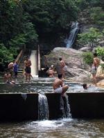
The waterfall can be reached easily from road nr 3 between Pasir Puteh and Kota Baharu. Access is also possible from road nr 4 between Jerteh and Marchang.
It is a popular destination for the people from Kota Baharu, so the fall can be crowded during weekends and school holidays.
tnimg_0940.jpg
The waterfall in the back is hardly visible.
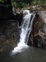
tnimg_0935.jpg
The waterfall itself is quite attractive.
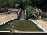
tnimg_0934.jpg
 One of the slides with a bathing pool.